- UN Food Security Agency
- Uganda Pilot · Expanding Nationally
Rosewill Bome Technologies case study
Robo Climate
AI-powered climate intelligence that fuses satellite data, IoT sensors, and predictive forecasting — built for governments and UN agencies operating at national scale
- Predictive forecasting engine
- AIPredictive forecasting engine
- Satellite data fusion
- IoT +Satellite data fusion
- Environmental monitoring
- 24/7Environmental monitoring
- Agency-supported pilot
- UNAgency-supported pilot
Active R&D — Prototyping & National Expansion
Following a successful Uganda pilot with UN food security agency support, Robo Climate is advancing toward broader government and humanitarian deployments.
When Climate Risk Becomes a National Security Priority
Rosewill Bome Technologies built Robo Climate for institutions that cannot afford fragmented data, delayed warnings, or black-box AI. It is enterprise-grade climate intelligence — designed for Africa's operational realities.
The Challenge
Across Africa, climate volatility is no longer a future risk — it is a present operational crisis. Ministries, UN agencies, and NGOs need to anticipate droughts, floods, and crop stress with enough lead time to mobilise resources. Yet most monitoring ecosystems remain siloed: satellite feeds in one system, ground sensors in another, and decision-makers left reconciling spreadsheets when communities need answers in hours.
Rosewill Bome Technologies was engaged to close that gap — delivering a single, sovereign-ready platform that turns raw environmental signals into actionable intelligence.
Our Solution
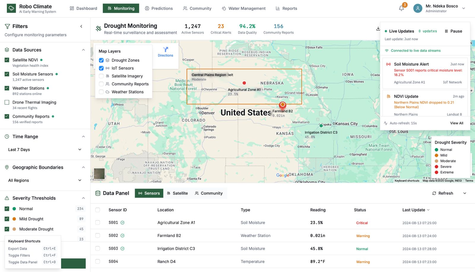
Robo Climate unifies IoT sensor networks, satellite remote sensing, and predictive AI into one climate intelligence stack. The platform is engineered for multilateral programme requirements: auditable models, role-based access, and dashboards that translate complex geospatial data into decisions ministers, programme directors, and field teams can act on immediately.
Platform Capabilities
Secure Climate Data Hub
Encrypted ingestion, storage, and processing of meteorological, hydrological, and environmental datasets — aligned to sovereign data governance requirements.
IoT & Ground Sensor Network
Ruggedised field sensors and telemetry integrations deliver continuous soil moisture, rainfall, and temperature readings from remote agricultural zones.
Satellite Intelligence Layer
Remote sensing pipelines fuse vegetation indices, land surface temperature, and precipitation anomalies into a unified geospatial climate picture.
Predictive AI Models
Machine learning models forecast drought onset, flood risk, and agro-meteorological stress windows — giving decision-makers weeks of lead time, not days.
Executive Decision Dashboard
Role-based dashboards for ministries, UN agencies, and NGOs — with map layers, alert thresholds, and exportable briefings for cabinet and donor reporting.
Automated Early Warning Alerts
Configurable SMS, email, and API-triggered alerts route actionable advisories to extension workers, district officials, and community responders.
What Institutions Get
- AI-powered drought and flood risk forecasting with explainable model outputs
- Real-time fusion of satellite imagery, weather APIs, and IoT ground-truth data
- Configurable early warning thresholds for district, national, and programme-level response
- Executive dashboards with map visualisation, trend analysis, and exportable reports
- API integrations for existing MIS, ERP, and humanitarian coordination platforms
Measured Impact
Act Before Crises Escalate
Timely drought and flood alerts give governments and humanitarian partners the lead time to pre-position food stocks, mobilise water resources, and protect vulnerable households.
Evidence for Policy & Donor Reporting
Standardised climate indicators and audit-ready data trails strengthen national adaptation strategies and multilateral programme accountability.
Protect Livelihoods & Food Security
Agro-meteorological intelligence helps farmers, cooperatives, and agriculture ministries adapt planting schedules and irrigation plans to shifting climate patterns.
Scale Across Sectors & Borders
Modular architecture supports agriculture, water management, energy planning, and disaster risk reduction — deployable nationally or across regional programmes.
Pilot Outcome — Uganda
Robo Climate's first innovation was successfully piloted in Uganda with support from a leading UN food security agency. The deployment demonstrated how integrated AI, IoT, and satellite intelligence can deliver actionable climate insights to strengthen national resilience — from ministry planning rooms to last-mile agricultural extension networks.
Building on this foundation, the platform is now scaling to serve additional governments, NGOs, and development finance partners seeking auditable, Africa-built climate technology that performs under real operational pressure.
Planning a Climate Intelligence Programme?
Speak with our team about drought observatories, early warning systems, and AI forecasting for governments, UN agencies, and humanitarian organisations.